Researchers in permafrost and geomatics at Department of Geosciences, University of Oslo use drones in their research. With the help of the drone they can take photos which are very useful.
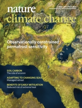
Recently an image taken from a drone is used as a cover photo for the May edition of the scientific journal Nature Climate Change. The photo show decreasing permafrost in the North of Norway, image taken autumn 2016 by Trond Eiken/Sebastian Westermann/Bernd Etzelmûller at field work in the research projects Permanor, SatPerm and COUP.
The image illustrates a research letter recently published in the Nature Climate Change journal.
Documentation of what happens on the ground
Aerial photos taken with the help of drones gives an overview over huge areas seen from above, and show what happens at the ground. Sebastian Westermann explains what is seen on the cover photo.
– The grey areas in the upper right corner represent palsas, i.e. permafrost mounds consisting of dry peat at the surface underlain by an ice-rich core. They are surrounded by a water-logged mire without permafrost, in colorful fall foliage. The palsas visible in the image slowly, but steadily erode in small thermokarst ponds, with blocks of peat collapsing in the water.

Aerial photos is also of importance for the students in geomatics at the department. In a MSc thesis by Amund F. Borge is it done a systematic analysis of aerial images since the 1950s. About half of the area covered by palsas in Finnmark has disappeared in the last 50 years.
This work is also described in an article in The Cryosphere; Strong degradation of palsas and peat plateaus in northern Norway during the last 60 years.

Useful drones
Images taken by drones are of invaluable help, and at the Department of Geosciences, the drone is a tool more and more used in research. The researchers can perform multiple flights at the same location at a certain time, and will then be able to observe changes over time, such as how fast a rock brook moves or movements in an unstable mountain side. They can take overlapping images and use such overlapping images to create digital landscape elevations, this technique is called photogrammetry.
At the Department of Geosciences students can learn techniques like this when taking the spesialization in geomatics in the geosciences studies.
The figure under show a 3D photo of a glacier with stones from a drone flight from September 2016, also here from Finnmark in the Northern part of Norway.

Reference to the research letter in Nature Climate Change:
Chadburn, S.E., Burke, E., J., Cox, P., M., Friedlingstein, P., Hugelius, G., & A. Westermann. 2017. An observation-based constraint on permafrost loss as a function of global warming. Nature Climate Change, 7, 340–344. doi:10.1038/nclimate3262