(N63°00’20”, E14°49’30”)
Age: Ordovician, early Caradoc.
Formed in a sea 500-700 m deep. Thus, the upper and major part of the crater developed in sea-water. The diameter of the apparent excavation in bedrock is about 7.5 km.
The bedrock consisted of about 80 m thick, limestone dominated, Cambrian and Ordovician beds that rested on an ancient peneplain of Proterozoic granite, dolerite, and metavolcanics. Granitic rock ejected from this inner crater forms a surrounding brim that is about 2.5 km wide to the north and west but much narrower to the east. This asymmetry suggests that the impact was oblique and came in from an easterly direction..
The ejecta that form the brim rest on the sub-Cambrian peneplain with only thin patches of Cambrian to Ordovician sediment preserved beneath the ejecta.. These circumstances are inferred to have been caused by removal of the bulk of the 80 m thick sediment sheet during excavation of the extensive water crater.
As a likely consequence of the dampening effect of the water on the impact shock, the shock metamorphism of the ejected granitic rocks in the brim is relatively low.
In a late stage of the excavation of the water crater there formed, in its peripheral parts, a characteristic breccia consisting of very local limestone and marl, mostly without admixture of fragments from elsewhere. Thus, the transmitted kinetic energy was enough to strongly stir the local rock but not to cause major horizontal mixing.
The principal effect of the following modification of the crater was the collapse of the water crater and its surrounding wall of ejected water. This highly energetic resurge process brought enormous masses of fragmented rock back into the crater. The flow began with clasts ranging up to over 1,000 metric tons and ended with well-sorted mud. The sandy fraction of the resurge deposit, which is quite thick and widely distributed in the area, carries the name ”loftarsten” in the local daily talk.
Lockne offers hitherto unique opportunities for field studies of an outcropping crater from a marine environment deep enough to appreciably influence aspects of the crater.
Based on local initiative an ambitious project has been launched in order to open the area for modern tourism. The project includes a highly professional museum with an engaging story to tell, and hiking facilities with instructive signposts.
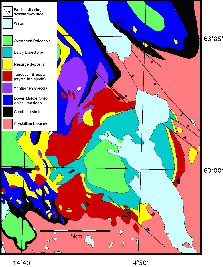
Geological map of the Lockne crater (Modified from Lindström et al., 2005). Note that the patches of Cambrian shale visible on the south-western flap occur at "windows" through the flap.
Selected references:
Lindström, M., 2003, Geoturist i Locknekratern. Geologiskt Forum 39, 14-23.
Lindström, M., and von Dalwigk, I., 2002, Geological guide to the Lockne and Dellen impact structures. Stockholm Contributions in Geology 47, 45 pp.
Lindström, M., Ormö, J., Sturkell, E., and von Dalwigk, I., 2005, The Lockne crater: Revision and reassessment of structure and impact stratigraphy. In: C. Koeberl and H. Henkel (Eds.): Impact Tectonics. Springer Verlag, Berlin-Heidelberg-New York, p. 357-388.
Ormö. J., Shuvalov, V., and Lindström, M., 2002, Numerical modeling for target water depth estimation of marine-target impact craters. Journal of Geophysical Research 107, E11.
Sturkell, E.F.F., and Ormö, J., 1998, Magnetometry of the marine, Ordovician, Lockne impact structure, Jämtland, Sweden. Journal of Applied Geophysics 38, 195-207.