
The University of Oslo is currently closed, and disputations will therefore be streamed directly using Zoom. The host will moderate the digital issues while the defense moderator chairs the defense.
Trial lecture
Machine learning applied to geophysical well log data for rock- and fluid-property estimation
Conferral summary
Seismic reflection data provide images of the Earth’s subsurface, from which geologists can map out geological structures of interest and interpret the geological evolution. The mapping of geological structures in seismic images is a time-consuming and often manual process. This dissertation deals with workflows for automatic interpretation of the seismic data. The candidate has developed digital tools and automated workflows that extract qualitative and quantitative information from seismic data. The workflows are based on signal processing, image processing and machine learning algorithms.
Main research findings
Popular scientific article about Bugge’s dissertation:
Aspects of automated seismic interpretation
To understand the Earth’s subsurface, geoscientists map out geological structures of interest and interpret its geological evolution from seismic images. These images are generated through acquisition and processing of seismic reflection data, where pressure waves are emitted and sent into the ground, and reflected back to the surface when hitting different geological strata.
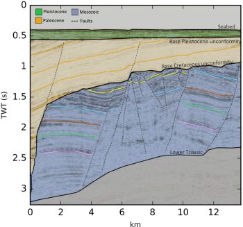
Credit: Lundin Norway AS
The interpretation of seismic images is a labor intensive and integrated process that requires geophysical experience and an intuitive geological understanding. While manual interpretation of seismic data often is essential in order to accumulate knowledge and build an understanding of the subsurface, some elements of the interpretation workflow can be tedious and partly trivial.
In this thesis, we present data-driven methods that seek to integrate data science and geoscience in order to address different aspects of automated seismic interpretation. These methods, based on digital tools from image processing, signal processing and machine learning, can be used to automate the interpretive workflow and to extract qualitative and quantitative information from seismic data without the need for manual user-interaction.
Photo and other information:
Press photo: Aina Juell Bugge, portrait; 500px. Photo: Simula
Other photo material: Figure with description and credit as specified in the article above, size 1000px.