In order to have better synoptic control and increased data-assimilation possibilities during the field phase, we plan to increase the frequency of vertical soundings at existing radiosonde sites at Bear Island (met.no), Ny-Ålesund (Alfred Wegener Institut) and the Kola Peninsula \(through the Finnish Meteorological Institute). New radiosondes are being explored on Franz Josef Land, in collaboration with the Arctic and Antarctic Research Institute (AARI) in Russia. AARI belongs to the Federal Service for Hydrometeorology and Environmental Monitoring of Russian Federation (Roshydromet).
We explore the use of a Coast Guard ship in the Barents Sea to carry meteorological instruments. The ship will carry a radiosonde launching station. Implementation of AMDAR-data from commercial aircraft will provide valuable information of the atmosphere, particularly near airports, and we will attempt to extend the current fleet of aircraft contributing with AMDAR data to also cover Longyearbyen, Kirkenes, Langnes and Alta. Radiosonde launches at Franz Josef Land (FJL), in collaboration with AARI, will, if successful, give a unique radio sounding of air masses well into the ice. These efforts are intended to provide an upstream vertical profile in northerly flows. It may turn out that this manned station will also be used by other IPY-projects, in this case the funding need can be modified. This will be clear as operational plans become clearer internationally in early 2007.
The plan would be to let an icebreaker take a meteorological crew to the Hayes Island on FJL in August 2007, returning one year later. The crew will be trained in radiosonde operations at the University of Bergen, summer 2007. Radiosondes will be launched on demand. As a legacy, the project aims at making the radiosonde launches operational if running costs can be secured after the IPY period. Reducing weather related risks in Russian oil exploration and production can be a driving force to secure permanent funding after IPY.
The observational network is sparse in the Arctic part of the North Atlantic and the Barents Sea due to the large ocean areas and the hostile environment. Remote sensing from satellites, based on e.g. SAR and scatterometer data provide indirect data for detailed wind fields, allowing accurate detection of fronts, and of detailed structures of gap-flows in the vicinity of topographic features.
Ships
The opportunity to have one ship in the region during the field campaign is being explored. The ship would launch radiosondes, in addition to carrying out standard meteorological observations.
Flux mast
If the NOAA P-3 aircraft is not available for the field experiment, we propose to erect a 30 m mast at a shoreline site on Svalbard, which will be exposed to open sea. This mast will record direct measurement of turbulent fluxes of wind, temperature, humidity (sonic anemometer, LICOR) together with slow response profile instruments, in addition to wave measurements. When the wind is onshore, the mast will record properties in the marine atmospheric boundary layer, to determine its sensitivity to the wave state (e.g. Smedman et. al., 1999; Sjöblom and Smedman, 2002; 2003). The site will be used to calibrate the DLR-Falcon LIDAR-system and satellite measurements. The recordings from this mast will outlive the project and leave a long-term record as a legacy for the future. UNIS will be responsible for future operation. The mast is planned as a stand-alone device, infrequently looked after. The A.M. Obukhov Institute of Atmospheric Physics RAS, the Academy of Sciences, Moscow (Dr Irina Repina) will measure atmospheric turbulent fluxes at sea-surface in the Marginal Ice Zone (MIZ) in the Russian sector of the Barents Sea (sites near Barentsburg, Spitsbergen; on Franz Josef Land (Heiss Island – Krenkel research station) and on the Novaya Zemlya meteorological station Malue Karmakylu) in spring 2008. A letter of intent is attached to this proposal.
Enhanced radiation measurements
We aim at deploying additional radiation instruments. Both terrestrial and solar irradiance will be measured at Bear Island. In addition, we seek to deploy, through a parallel IPY project, similar instruments on weather ship OWS Mike, having gyro-stabilizers and separate recordings of heave, pitch and roll. Comparison with satellite information and numerical models will give us valuable information for calibration and detection of systematical errors in the radiation schemes of the numerical weather prediction models.
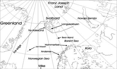 Area of interest, displaying geographical names appearing in the text.
Mobile instrumental platforms
Manned Aircraft
The first Manned Aircraft (MA) (DLR-Falcon) will be operating from Andøya. It is equipped with an in-situ standard meteorological platform, a LIDAR-platform and with dropsonde possibilities. The MA is planned to be operating for three weeks in February and March 2008. Hopefully, additional funding being sought from EUFAR or collaboration with other partners will extend the stay somewhat.
The main task for the MA is to make on-demand in-situ measurements and to drop sondes from high altitudes documenting the vertical structures of Arctic fronts, polar lows and flow distortion over Spitsbergen. The newly developed LIDAR platform is able to measure a vertical profile of latent heat fluxes over the ocean (C. Kiemle, DLR; pers.comm.), as well as a rough estimate of cloud microphysical properties. Comparison with the troposphere-LIDARs at ALOMAR-Andenes and Ny-Ålesund will provide a valuable calibration opportunity. The LIDAR capabilities will link the Falcon aircraft activity to many of the Work Packages in the proposal. At low altitudes, the aircraft may encounter icing problems over the ocean, constraining the operation altitude. However, to the extent the aircraft may operate at these levels, in-situ observations over the ocean will be recorded. Particular interests will be across the leading edge of cold air as it moves southwards, and gap-flows and flank-jets connected to Spitsbergen.
The second manned aircraft (NOAA P-3) will complement the DLR Falcon. The P-3 is an extremely robust and well-tested aircraft, which has been flown into hurricanes in the Gulf of Mexico for three decades, as described in a recent article in BAMS (Aberson et al., 2006). It is able to fly through severe weather, and it can fly close to the ocean surface, carrying out measurements of turbulent fluxes. Furthermore, the P-3 has a much longer flight range than the Falcon, yielding large flexibility in operations. It is a well-equipped aircraft, which is able to release dropsondes, but it does not have the unique LIDAR instrumentation of the Falcon. All in all, the two aircraft complement each other extremely well, and will be a major asset to our campaign. Due to current uncertainty regarding funding of the P-3, we have a “plan B”, which consists of using a flux mast and radiation instruments to be deployed at Bear Island, for measuring fluxes, in case the P-3 aircraft is not available.
The Small Unmanned Meteorological Observer (SUMO)
The Small Unmanned Meteorological Observer SUMO has been developed as a substitute for usual radiosonde systems for atmospheric boundary layer research, where we are only interested in the vertical structure of the important meteorological parameters temperature, humidity and wind in the lowest 1 or 2 km of the atmosphere. First of all the use of radiosondes, that can measure up to 25 km altitude, is simply a waste of money and resources for such purposes. Besides this economic dimension SUMO provides further advantages compared to radiosondes. It is actively controlled and can measure in a well defined atmospheric column over one point, while the radiosonde will be moved with the wind. SUMO is also capable of flying complex and predefined scientific missions (cross-sections at given altitudes; horizontal surveys of larger areas) that cannot be achieved by other means. And of course SUMO returns after the mission to its starting point, while the radiosonde is lost.
SUMO is basically a commercially available model airplane with 75 cm length and 80 cm wingspan equipped with an open source autopilot system (Paparazzi; http://paparazzi.enac.fr/wiki/Main_Page) and sensors for temperature, humidity and pressure. It is electrically powered and has an endurance of around 25 minutes which enables operation of the system up to 3.5 km above ground. With a total start-off weight of 580 g (including motor and batteries) it is after our knowledge the world’s smallest research aircraft. By lying in circles with constant throttle, we also can determine wind speed and direction, because headwind will decelerate and tailwind accelerate the speed of the aircraft above ground measured by the GPS system.
SUMO has now been operated during several international measurement campaigns (FLOHOF 2007 on Iceland; IPY-THORPEX 2008 on and around Svalbard; FLUXPAT 2008 nearby Cologne, Germany; GFI-THORPEX 2009 on Svalbard) and has performed several hundreds of successful meteorological measurement flights. On Svalbard we have now performed 90 flights and got atmospheric profiles of temperature, humidity and wind up to 1500 m above ground. This altitude was the limit due to regulations of the Civil Aviation Authority of Norway.
Tethered balloon system
We plan to operate a tethered balloon system (developed by Spec Inc.) at Ny-Ålesund (Professor Jakob Stamnes, UiB). The system will record radiation and cloud microphysical properties in addition to regular meteorological parameters. When in operation, the tethered balloon will continuously make soundings up to an altitude of 1-2 km, depending on wind conditions. The balloon system consists of a miniaturized cloud particle imager (CPI) which identifies particle shapes and sizes as well as a 4-π unit which observes the radiance in 6 directions. In addition, a meteorological package sampling pressure, temperature, humidity, wind and position is carried. By locating the soundings at Ny-Ålesund, we expect to be able to do an inter-comparison with the LIDAR-system run by AWI at this site. The dataset obtained during the field and laboratory measurements will be used in modelling efforts to improve existing parameterizations of the absorption and scattering coefficients of clouds, snow, and ice due to changes in temperature and biological activity. These parameterizations will be implemented in radiative transfer models to evaluate the overall impact of changed inherent optical properties on the net radiation and the surface energy budget in the Arctic.
Drifting buoys
We are exploring the possibility of deploying drifting buoys in the Barents Sea, for meteorological and surface current observations. Data from the International Arctic Bouy Programme (IABP) are transmitted via WMO GTS-system in real time and will be an integrated part of the observation programme (http://iabp.apl.washington.edu).