Introduction
The history of fault growth in sedimentary basins can be constrained by combining different techniques; assessing sedimentary thickness distribution by calculating expansion indices (growth wedges), mapping unconformities and correlative conformities (footwall uplift vs. hanging wall subsidence) and examining fault-related folding of affected sedimentary strata (fault segmentation, linkage and shape).
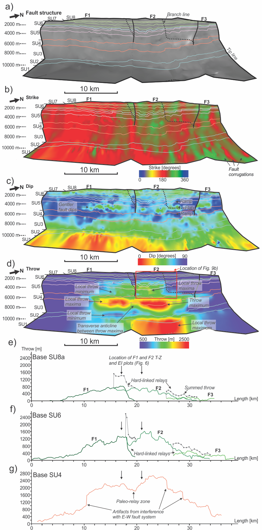
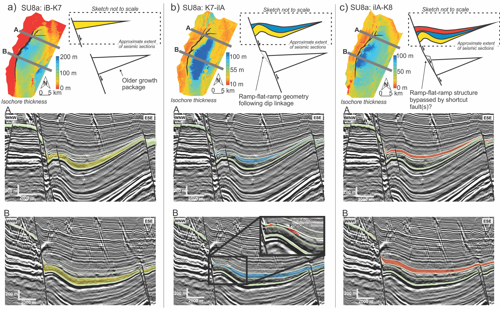
Furthermore, quantitative fault analysis gives the relation between fault strike, dip, displacement, depth and length in 2D and/or 3D plots (Fig. 1). Conventional seismic data provides an opportunity to examine displacement variations on a fault plane, albeit only with a typical vertical resolution of 25-80 m, depending on a variety of factors. Faults grow in the subsurface through a series of slip events (earthquakes). Slip events in extensional faults may result in fault displacements up to a few meters.
Utilizing high-resolution seismic data for quantitative fault analysis allows for examination of fault growth at the scale of single fault slip events, which is unobtainable in conventional seismic data.
Aims
This project will analyse faults and stratigraphy within the Maud Basin (SW Barents Sea) to decipher the history of fault growth and accommodation development.
Objectives
- Map faults and stratigraphic surfaces on conventional and high-resolution 3D seismic data.
- Generate isopach maps.
- Generate a seismic-stratigraphic framework through ties to nearby exploration wells.
- Perform detailed quantitative fault analysis of selected faults to inform fault nucleation, growth, segmentation and linkage, generating an array of fault attributes; strike, dip, displacement vs. length, displacement vs. depth, expansion index (Fig. 1).
- Assess fault-related folding of footwall and hanging wall stratigraphy in relation to fault morphology (Fig. 2).
- Consider interpretation discrepancies between conventional and high-resolution 3D data.
- Consider the value of high-resolution 3D data in an earthquake geohazard context.
Data
The project will utilize in-house high-resolution 3D data and conventional 3D data from the northern margin of the Maud Basin, SW Barents Sea. Well log data from nearby exploration wells (Wisting discovery). Litterature on extensional fault development, seismology in extensional provinces and evolution of the SW Barents Sea.
Tools and methods
Seismic interpretation will be conducted using Schlumberger’s Petrel E&P software. Fault attributes will be generated using Badley’s T7 and/or Petex Move.
Learning outcomes
In-depth knowledge of fault analysis; fault growth, extensional basin evolution, the seismology of extensional provinces. Software proficiency: Petrel, T7, Move. Skillsets within independent academic research, writing and presentation of results.
Click here for a bigger version of the picture.
Click here for a bigger version of the picture.