
Universitetet i Oslo er for tiden stengt, og disputasen vil derfor bli strømmet direkte via Zoom. Verten vil moderere det digitale mens disputaslederen moderer disputasen.
Ex auditorio-spørsmål: Disputasleder vil invitere til ex auditorio-spørsmål, og disse kan foretas enten skriftlig eller muntlig ved å klikke "Participants -> Raise hand".
Prøveforelesning
Machine learning applied to geophysical well log data for rock- and fluid-property estimation
Kreeringssammendrag
Seismisk avbildning er en geofysisk metode for å kartlegge geologiske strukturer i undergrunnen. Tolkning av seismiske data er arbeidsintensivt og gjøres ofte manuelt. Denne avhandlingen omhandler fremgangsmåter for automatisk tolkning av seismiske data. Kandidaten har utviklet digitale metoder og verktøy for å ekstrahere kvalitativ og kvantitativ informasjon fra seismiske bilder. Metodene er basert på signalprosessering-, bildebehandling- og maskinlæringalgoritmer.
Hovedfunn
Populærvitenskapelig artikkel om Bugges avhandling:
Aspects of automated seismic interpretation
To understand the Earth’s subsurface, geoscientists map out geological structures of interest and interpret its geological evolution from seismic images. These images are generated through acquisition and processing of seismic reflection data, where pressure waves are emitted and sent into the ground, and reflected back to the surface when hitting different geological strata.
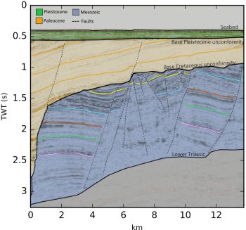
Credit: Lundin Norway AS
The interpretation of seismic images is a labor intensive and integrated process that requires geophysical experience and an intuitive geological understanding. While manual interpretation of seismic data often is essential in order to accumulate knowledge and build an understanding of the subsurface, some elements of the interpretation workflow can be tedious and partly trivial.
In this thesis, we present data-driven methods that seek to integrate data science and geoscience in order to address different aspects of automated seismic interpretation. These methods, based on digital tools from image processing, signal processing and machine learning, can be used to automate the interpretive workflow and to extract qualitative and quantitative information from seismic data without the need for manual user-interaction.
Foto og annen informasjon:
Pressefoto: Aina Juell Bugge, portrett; 500px. Foto: Simula
Annet bildemateriale: Figur med beskrivelse og kreditering som spesifisert i artikkelen over, størrelse 1000px.