The project is cross-disciplinary and integrates the common underlying physical principles for image formation into image analysis. This benefits both image formation, where iterative processing will be used to produce better images, and image analysis and interpretation, where the physics involved in image formation will be used in deriving better feature extraction and image classification methods.
The main goals of this project are:
- To demonstrate the potential of integrated image formation/interpretation on sonar and seismic imaging.
- To develop new, efficient and accurate iterative seismic imaging methods for the special case of salt tectonics.
- To develop new sonar image analysis techniques in conjunction with refinement of enhancement techniques for sonar image feature extraction.
The project consists of three work packages:
WP 1 Integrated seismic image formation
Formation of seismic images under salt bodies, overthrust sediments, and other strongly refracting overburdens is substantially more difficult than image formation in less geometrically complex settings. A considerable part of the remaining frontier petroleum resources are likely to be found in such structurally complex zones.
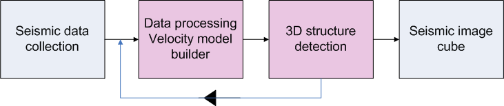
Imaging of seismic data employing advanced methods like prestack depth migration is computer intensive and time consuming. Hence, speeding up the process of building velocity-models for complex models is a very important task to make iterative imaging feasible and accurate. New methods that can automate this process and possibly be integrated as part of the imaging method, will represent a significant improvement. The overall goal of this work package is thus to develop new iterative imaging methods for the special case of salt tectonics which are both efficient and accurate.
Methods for detection of 3-D structures in seismic will be developed. The tracked structures will be interfaced to the velocity model builder to increase its accuracy, and prestack depth migration of the seismic data based on the current tracking/velocity-model will then be performed. An iterative procedure will be implemented based on these main steps.
WP 2 Integrated sonar image formation
By introducing synthetic aperture sonar (SAS), new possibilities for mapping and classification of the seafloor arise. A fundamental property of SAS is that the image resolution becomes independent of range and frequency. This, in addition to the dramatic improvement in resolution, opens for new methods and techniques in image analysis and feature extraction of SAS images.
The main goal of this work package is to develop new image analysis techniques in conjunction to refinement of enhancement techniques (Hansen, 2007) for SAS image feature extraction (as outlined in the diagram below). The multidimensional properties of the sensor data will be explored and used in the image analysis. The primary application for this is improved feature extraction in seafloor classification.